A little behind on the blog this week. (It is always convenient that when I don't post,
Silver Spring, Singular and
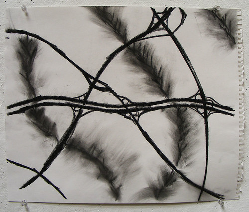
Thayer Avenue do, and vice versa.) But I thought it would be nice to show you what I do in school. I am taking an art class this semester, which has enabled me to tackle some local issues with the media of charcoal:

Bonus points if you can guess where this is. No cheating with maps, though you can probably figure it out from the process drawings below:


5 comments:
most definitely the 4 corners area
That "Going Home" diagram reminds me of old pre-photographic military maps.
Contrast and compare!
Easy...it's a map (sans labels and w/topo) showing the Beltway, Colesville Rd, University Blvd, New Hampshire Ave and the interchanges where each intersect. You've also shown the Sligo Creek stream valley and the Northwest Branch/Paint Branch Stream valley. Nice work! And they say you architects don't know nuttin' bout the land. You'd make Frederick Law Olmsted proud.
Hmm. Dan and I and doubtless many others as well, have had the discussion about how if you want to understand planning in MoCo, you have to understand the lay of the land, where the stream valleys are.
Also you have to understand how reluctant the County is to approve any bridge across any stream -- no matter how trifling the stream or proposed bridge.
Dan covered this very well last year in his article to the effect of "why I can't walk to Marilyn Praisner's house.
Here's a fun little image I generated from the freeware GRASS GIS software, combining USGS topographic data, with TIGER Census vector line data draped over the 3D model. It's from a set of computationally generated maps of Aspen Hill and environs.
Note that this depicts the shortest portage between the Rock Creek watershed and the NW Branch of Anacostia watershed.
Note how few bridges there are across the streams.
Obviously, in some places, bridges will be very expensive and must be funded by State or Federal programs. If I recall correctly, the Beltway bridge over the NW Branch of Anacostia stream valley is one of the three highest bridges east of the Mississippi.
Dan, your attention to the detail of the stream valleys is extra-commendable.
So, where would you want to add additional bridging, the inexpensive bike-and-foot-bridge kinds, in District 4? Ya know, so you could at long last walk to visit the old Praisner homestead?
Cool drawing.
So what does "You can't get there, from here" sound like in a Maryland accent?
There must be a conditional on the height of the NW branch beltway bridge - as I can think of many taller ones ... maybe highest single-span bridge? Think of the Susquehannah bridge on I-95 (or the Bay Bridge!).
Post a Comment