
All I wanted to do Sunday afternoon was go to a place that had water. At first, I thought about going to Annapolis, but then I remembered: we have a river right here! The Patuxent River, which you've probably driven over a million times going to and from Howard County. But as present as it is in my life, I'd never thought about how difficult it is to go down by the River Pax.
I started at Burtonsville Park, about a mile from the river at Route 198 and Oursler Drive. There was a playground with some kids and some picnic tables, a parking lot or two - and some woods that I figure continued to the water, but no trail, no signs. Okay, I thought. Let me find the next closest place where you can cross the river, which was Ednor Road.
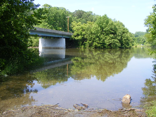
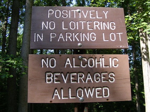 A few more minutes of driving, windows down, these awesome friendly summer breezes that won't hang around for too much longer. Where Ednor Road meets the river are parking lots - one on each side of the road. On the east side is a boat slip; on the west side, a bridle path. Signs for both make it explicitly clear that if you don't have a boat, a horse, or a use permit, you're not welcome there. "POSITIVELY NO LOITERING," says one sign. But isn't that why I'm coming to the Great Outdoors . . . to stand around and appreciate God's green earth? So I took some pictures and gave up. I got shaved ice from the snowball stand outside Kendall's Hardware in Clarksville. (Mmm, summer.)
Nowhere else in Montgomery County are there as many people near the water as there are here. (Sure, there's a good chunk of Bethesda and Potomac along the Potomac River, but unlike us, they have to cross a highway, albeit a very pretty drive, to reach it.) Between Burtonsville Park and Burtonsville's dying Village Center there seem to me a slew of opportunities for us to interact with the water: hiker/biker trails along the shore, little beaches, even fishing piers. And the paths we build could snake over to Old Town Laurel, where they could really embrace the Patuxent with a boardwalk lined with shops and restaurants.
so much more AFTER THE JUMP . . .
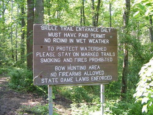 But, as it stands, we have a river that's largely hidden and inaccessible to the public. The Montgomery County Park and Planning Commission has little claim to the Patuxent, aside from conservation land meant to keep the river's tributaries clean. Of course, our water comes from the Tridelphia and Rocky Gorge reservoirs, which were formed by dams built in the 1940's. The Washington Suburban Sanitary Commission (you know, the water company) has control over them, and have set up the very unfun-sounding "Watershed Recreational User Program," which enables visitors to go boating, fishing, hunting and horseback riding along the river for a small fee. They have picnic tables, apparently, but when I was at Ednor Road, I didn't see any sign directing me to them.
The Patuxent River State Park starts at Georgia Avenue north of Brookeville and continues west to Damascus. You can go boating, fishing or hunting there - but there are also plenty of picnic areas and hiking trails. This is a place where you can reach the water - with ease, I'm sure - but only if you know to go there. For anyone living east of Georgia Avenue, going down to the river is a much more complicated proposition.
I understand the health of the river is important for protecting our drinking water - and, more importantly, the status of the Chesapeake Bay eighty miles downstream. But for the practical and recreational benefits it provides, it seems like the Patuxent River is woefully underused in East County. There are thousands of people who live within a ten-minute drive of the river itself but, instead, have to go miles away just to set out a picnic blanket.
7 comments:
I definitely agree. My friend and I tried to bike to the Patuxent, taking Oursler Drive, and ended up at some farms where people kinda looked at us funny. There's just no easy way to access the Patuxent near Burtonsville, aside from little known dirt paths that the residents there likely made.
If you are looking for water, the Paint Branch stream has a paved path from Fairland Rd to MLK Jr Park, with wooden bridges and picnic tables along the way. North of Fairland Rd, the stream is near a few windy dirt paths through the forest that I've traversed that can get you to Briggs Chaney Rd (sadly though, ICC construction will be going through that forest). You can keep going from there to get near Miles Rd and then to Greencastle Rd, if you're up for an adventure :) But yeah, there aren't any large parks near Burtonsville for boating, fishing and the such, which is disappointing, esp. with the large Patuxent River so close.
Nice plug Dan! That's one of the reasons I left Easter MoCo ( on Western LoCo VA)
In my time there not once did I make it down to the the river
S
Did you see Matt Foley's van?
If you wanted to go a bit farther out, the area at Brighton Dam is nice. Go out New Hampshire Avenue a few miles past Ashton and turn right on Brighton Dam road. They have a grassy picnic area, a larger boating area, and a huge azalea garden in the woods.
Where Ednor Road crosses the Patuxent right where it enters the T. Howard Duckett Reservoir, that has been a "party place" for at probably 4 decades now. It waxes and wanes in popularity, and as long as people don't hang around in the parking lot, the WSSC folks don't much care what you do as long as it doesn't pollute the water supply.
However, every now and then, some dufus thinks s/he is being original when they think "hmm I think I'll set up shop and start dealing up at the Ednor Road crossing", etc. Then there are the people who figure that it's a great place for fooling around in the back seat of the car, etc. Worst idea evar.
As for getting to the river at Burtonsville, many years ago this gal took me up one of the roads that fronted along it, and we had to park about a mile from where we got on the path to the river. That was a long hike, but actually delightful as the trail led along a tiny brook and the trail and brook crossed each other quite a few time. At the river, the swimming was great, for about two minutes before some ranger in a boat showed up and ran us off, threatening us with some ungodly huge fine as well as a trespassing charge.
The thing is, it's a very long and really quite clean river, not suprisingly it's kept so clean by people who really like to drink water that they reasonably believe hasn't had people swimming in it and doing who knows what else (insert unsavory speculations, here) while they were at it.
Rock Creek and its tributaries are pretty nice in parts. For example, not easy to drive to -- same reasons as with the Ednor Road lots -- there is Lake Bernard Frank, but don't try to swim there unless you maybe want a free polycythemia (sp?) treatment; you'll come out covered with leeches. Or is that Lake Needwood? But the fishing is good and the trails are pretty nice.
For that matter, you could always go to the Northwest Branch stream park in the vicinity of Layhill, all very nice whether you are playing golf or just wandering around along the stream banks. Just don't be there in a thunderstorm or a flash flood might sweep you miles downstream.
What's even more a shame is that WSSC makes it so difficult to follow the rules at the Ednor Road and Brighton Dam spots. I just bought a kayak over the winter, and I wanted to paddle in Triadelphia & Rocky Gorge. I have to drive almost 20 miles round trip to get the required $5 day permit. I would have gotten one for the year, but if I take a different person with me in my second kayak, each *person* (rather than the boat) requires another permit. I asked if I could buy a stack of the day passes, and he said "only if you tell me what days you'll be out there right now."
The 10 mile drive up to Brighton Dam from Silver Spring pretty much precludes every kayaking on a weekday evening after work now, so I just have to go to the Potomac instead.
I am always astounded when I hear people bitching about rules intended to preserve the safety of the drinking water supply of a million or more people.
Why don't you just agitate for the freedom to fly with shoes made of dynamite. Oh, and to carry bottles of gelignite disguised as shampoo.
Seriously: In a day and age where hepatitis B and C are so widespread as to be ubiquitous, maybe it's just not a good idea to let just any old everyone fall out of a canoe into the drinking water, mmmkay?
Each *person* needs their own permit because each *person* needs to be backgrounded to see if they've got some predeliction to terrorism -- you know, like those nuns who've never been to Maryland that the State Police infiltrators put on the mid-Atlantic drug-trafficking watchlist -- or maybe an active case of Lyme Disease or hepatitis-B. Or lots of other things.
As for the Potomac, go ahead and kayak there. It has a measurable caffeine content and the fish are all trisexual. There's not much more anyone could do to it to screw it up more.
Post a Comment