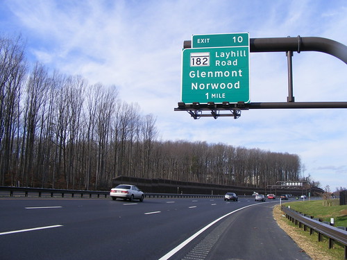
UPDATE: A very nice gentleman named Vic Seested sent an e-mail to Post reporter Katie Shaver (who then forwarded it to me) calling us both out for our blatant ignorance of local history:
your article in the post today-destination unknown has to be one of the worst researched i've read in some time. you had the misfortune of not getting up from your desk and from talking with some really stupid clueless people. facts. at the intersection of "norwood rd and 182" is the old maryland state police medivac factility. the sign which is still there says "norwood division". where did they pull that one from. next, the road at the intersection of 182 and "NORWOOD RD" might be a clue that there was/is something called norwood at one time. guess what. about 1/2 mile up norwood rd, not far from the idiot at the sandy spring museum, which is 1/2 mile from norwood road is a maryland/montgomery county historic home. guess what the name is? NORWOOD. guess why the area is called norwood? the newcomers like the 20 something has no history and no sense of history. thank god he is working on city planning. he could be working on nuclear defense. see the attached. vic seested
Thanks, Vic. (And thanks for the follow-up e-mail you sent me explaining that there "is no cure for stupid.")
POST: Check out the Weekend section in today's Washington Post. There's an interesting article by Katie Shaver on the forgotten village of Norwood, brought back to life by an exit sign on the InterCounty Connector. And it features a few quotes from yours truly since I blogged about it last month:
Just Up the Pike blogger Dan Reed, who grew up in the area, said the sign piqued his interest when he tried out the ICC while home for Thanksgiving from the University of Pennsylvania . . .
He said he thinks of the influence that the names of Metrorail stations, such as White Flint in North Bethesda, have had in identifying communities.
“I’d be curious,” Reed said, “if in 20 years people say, ‘I live in Norwood,’ because of the highway sign.”
More interesting is the explanation from Scott Crumley, lead traffic engineer for the toll highway, as to how the Norwood exit got its name:
Scott Crumley, the ICC project’s lead traffic engineer, said state highway planners and ICC officials thought of Norwood in 2005, when the state was drafting the project’s bid documents . . .
Notes from numerous meetings about the exit signs show that Ashton was considered a natural northern destination for the New Hampshire Avenue (Route 650) exit and that Olney was noted to be due north of the ICC via the Georgia Avenue (Route 97) exit.
“If you look at 182 [Layhill Road], it doesn’t go to Ashton. It doesn’t go to Olney. It really doesn’t go to Sandy Spring,” Crumley said. Norwood, which he said is on U.S. Postal Service maps even though it no longer has a post office, “was kind of the best of what they had to work with.”
That makes enough sense. Special thanks go to Katie Shaver for doing the research that my Google searches couldn't, but also for giving me a shout-out. I'm glad that our local newspapers are willing to work with local bloggers.

1 comment:
Interesting they made a big deal about a place called Norwood, referencing another place that doesn't exist. White Flint is in Kensington. There is no such place as "North Bethesda."
Post a Comment