Monday, September 21, 2015

the silver spring transit center is finally open!

After years of delay and budget overruns, the Silver Spring Transit Center finally opened yesterday.

DSC_0500
Photo by BeyondDC on Flickr.

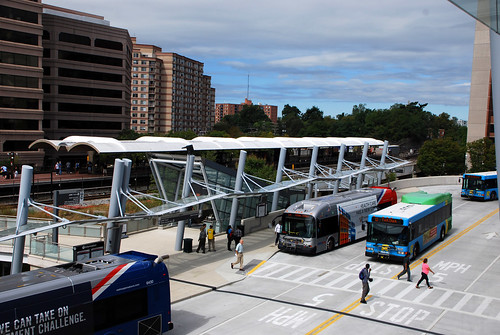
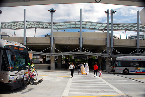
The three-story complex, located next to the Silver Spring Metro station, brings together Metro, MARC commuter rail, local and intercity buses, and a kiss-and-ride. The future Purple Line will also stop there. First proposed in 1996, construction started in 2008.

The transit center was supposed to open in 2012 before officials found serious structural defects. A report found that the county, the designers, and the builders were all at fault, and WMATA refused to take over the building. The county brought in a new structural engineer to organize repairs, which began last fall. Right now, Montgomery County and WMATA are suing the builder and designer.

DSC_0466
Photo by BeyondDC on Flickr.

But now, the transit center is up and running after a low-key opening Sunday morning. The first bus, a Metrobus 70 headed to Archives, pulled out at 4:08 am. Later in the morning, the Action Committee for Transit announced the winner of its contest to guess the transit center's opening date: Garth Burleyson of Colesville, who'd picked October 26.

Monday, September 14, 2015

dc's "little ethiopia" moves to silver spring and alexandria

Historically, the DC area's Ethiopian diaspora has centered on Adams Morgan and Shaw. But as the community has grown, it's mostly moved out of the District. Today, the region actually has two "Little Ethiopias:" one in Silver Spring and one in Alexandria.

Where the region's Ethiopian population lives. Map by the author.


Ethiopians have a lot of roots in the DC area

Ethiopians first began moving to the United States in the 1970s, fleeing a military dictatorship. The DC area has the nation's largest Ethiopian community, but just how big it is up for debate.

The 2013 American Community Survey found about 40,000 people of Ethiopian ancestry in the region, while the Arlington-based Ethiopian Community Development Center says there are 100,000 Ethiopians living in the area.

There's also a large population from Eritrea, which broke off from Ethiopia in 1991. The Census doesn't break out ancestry data for Eritreans for local areas. But in 2005, but the Population Reference Bureau estimated that about 2% of African-born blacks in the region, or about 2,300 people, came from Eritrea.

Today, Ethiopians are the largest African immigrant group in the region, making up one-fifth of the region's African diaspora. There are about 1200 Ethiopian-owned businesses in the region, according to the ECDC, as well as the Ethiopian community's own Yellow Pages. Famous Ethiopian entertainers have settled in the area, and major events serving the diaspora are held here, like this sports and live music festival that was at the University of Maryland this summer.

Tuesday, September 8, 2015

another take on which parts of the DC area are "urban" or "suburban"

Last month, I used housing density to map the real boundaries between "urban" and "suburban" in the DC area. But what if you took other factors into consideration? This map looks a little different, but still shows that there's more "city" than what's inside the DC line.

Who are you calling suburban? (Jed Kolko's data)
How economist Jed Kolko would classify "urban" and "suburban" parts of the region. Map by the author with Kolko's data.


My maps are based on research from Jed Kolko, chief economist at Trulia, who mapped several other metropolitan areas around the country. He reached out to me with his own data for the DC area, which is available on his website. While I only looked at housing density as a measure of urbanism, Kolko included several other factors, including the density of jobs and businesses, how many people go to work without a car, and the presence of multi-family housing.

Compare Kolko's map to my map below. One big difference is that his analysis only goes to the zip code level, while I used Census tracts. That makes my map is a little finer-grained, focusing on neighborhoods as opposed to larger areas. And while he agrees that there are "urban" places well outside the District, Kolko's analysis finds fewer of them, particularly in Northern Virginia.

Who are you calling suburban? (Updated)
My earlier map, looking solely at housing density.

Kolko classifies all of the District, Arlington, and Alexandria as "urban," even areas that are pretty spread-out and arguably suburban in character, like the Palisades in northwest DC. Like me, he also includes several older communities in Maryland that originally developed around streetcar lines and as a result look very similar to urban neighborhoods in DC, like Hyattsville, Silver Spring, and Bethesda.

My map also identified many newer communities that are gaining more urban characteristics, like White Flint in Maryland or Tysons Corner in Virginia. Kolko includes several of those places in Maryland, but not a single one in Virginia. In fact, he doesn't consider anything in Fairfax County "urban."

I wasn't the only blogger to look at housing density as a measure for urbanism. NextSTL, a St. Louis-area blog, made a similar map and found that "urbanism" can be found on both sides of the city line there too.


What do you see in these maps? What factors do you consider make a place "urban" or "suburban"?