
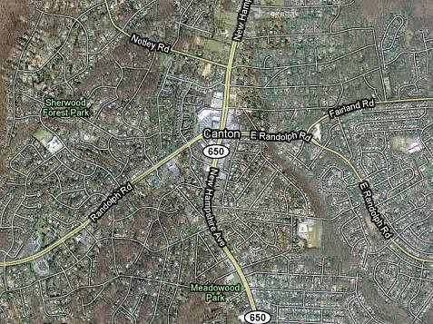
- Colesville and a town in Ohio have switched names, according to Google Maps. The Canton Repository reported last week that their town was appearing as "Colesville" on the map website, which updated their symbols and place designations last week. Meanwhile, if you type in "Colesville, MD," it'll take you to the right place - the crossroads at New Hampshire Avenue and Randolph Road that usually takes a Silver Spring address - but it'll say Canton. While a slew of complaints from Ohio got their label fixed, Canton, Maryland remains.
- Greater Greater writes about a church in McLean that's exploring ways to turn its suburban campus into a small, mixed-use neighborhood. That might be useful for the large houses of worship along New Hampshire Avenue, the so-called "highway to heaven." Giving their congregants more opportunities to live nearby (other than large single-family homes) could reduce local traffic AND build stronger religious communities. The First Baptist Church's 2005 proposal to build apartments on their property at Wayne and Fenton failed, though a church in Clarendon broke ground on a similar project last month.
- The Department of Parks is holding a community meeting to discuss a temporary skate spot that'll be built in Woodside Park this winter. That meeting's at 7pm Wednesday at the Park and Planning Commission, located across from the park at Spring and Georgia.
- Samuel Myers, better known as Bonifant Street dry-cleaner Jim Dandy, will receive the 2009 Neal Potter Path of Achievement Award this year. Named for the former County Executive, the prize honors Montgomery County residents over 60 who have contributed to their community.
Ninety-four years old, Myers has owned the cleaners since 1972 but will have to leave soon as his and several other businesses along Bonifant are cleared to make way for a new apartment building. He'll be recognized in a ceremony at 4pm Thursday in the Music Center at Strathmore at Rockville Pike and Tuckerman Lane in North Bethesda.
3 comments:
Google Maps now has a lot of strange stuff in Silver Spring. The Silver Spring library was (maybe still is) shown as on the west side of Colesville Road where a house is. There is also a house with a "Prince Georges County Government" label in Four Corners.
The library is on the correct side of the street, but of course it is labeled "Silver Springs Library"...
Google maps and Mapquest numbers East Silver Spring blocks backwards -- I've sent in corrections for years. It is infuriating. The have the right the high numbder say 756 at the East end of the blocks and the low end say 701 at the West end. So 856 is sharing the next corner to 701 does that make any sense?
If you live mid-block, you prob don't notice and have no problems. For those of us on either ends ofthe block it is a pain for deliveries and guests.
Post a Comment