Showing posts with label calverton. Show all posts

Monday, April 18, 2022

east county could get a new grocery store and senior housing, and some neighbors fear the worst

Montgomery County envisions a new town center along Route 29 in White Oak, and after a decade, plans are finally moving forward. But at one local church, there's a disagreement about whether "love thy neighbor" extends to a proposed development next door. 

A rendering of the proposed grocery store and senior apartments, with East Randolph Road on the right. All images from the Planning Board report.

This Thursday, the Planning Board will hold a public hearing on and review Conley Square, a proposal to build a small grocery store and 234 homes, including affordable senior apartments, townhomes, and stacked townhomes at the intersection of Old Columbia Pike and East Randolph Road. Today the vacant 11-acre property is zoned for single-family homes on half-acre lots, so the board will recommend whether to rezone the nearly 11-acre property to allow mixed-use development ahead of a hearing at the Board of Appeals on May 2.

If built, Conley Square would be one of the first new developments along Flash, a bus rapid transit line between downtown Silver Spring and Burtonsville that opened in 2020. It’s next to the Tech Road station and a few other projects moving forward, including a shopping center with an Amazon Fresh grocery store and 390 apartments and stacked townhomes.

People are mad

Over the past month, members at the Southern Asian Seventh-Day Adventist Church - which sits next door to the proposed development and would share an entrance with it - have sent form letters to the Planning Board opposing it.

The letters claim that a new grocery store and homes will “will bring in undesirable people into the peaceful surrounding,” adding, “Some of the concerns are drugs, prostitution, vandalism, theft, and crimes.” Some letters implied that, as many members are of East Indian descent, the development would lead to anti-Asian violence.

Wednesday, September 16, 2020

flash, maryland’s first bus rapid transit line, is almost finished

Maryland’s first Bus Rapid Transit line will open in Montgomery County later this year. Let’s take a look at one of the stations under construction.

Rear of April Lane Flash BRT platform
The April Lane station on Flash, Maryland's first bus rapid transit line. Click here for a slideshow. All photos by the author.

Under construction since 2018, Flash BRT is an 14-mile line that will run along Route 29 (Colesville Road and Columbia Pike) from the Silver Spring Metro station to Burtonsville, making 11 stops along the way.

It’s the first of three lines Montgomery County is working on - the other two are on Veirs Mill Road between Wheaton and Rockville, and along Route 355 between Bethesda and Clarksburg. Route 29 is one of the busiest bus corridors in the region, and Flash buses will come every 7.5 minutes during rush hour and run from 5am to midnight.

One of the stations will be April Lane, located on Lockwood Drive in White Oak where buses will briefly detour to serve a large cluster of apartment complexes. When I stopped by in August, the station (or stations, since there are platforms on both sides of the street) was almost finished, save for a few signs that hadn’t been installed and some construction debris.

Monday, October 16, 2017

see what montgomery county's new BRT stations will look like

Montgomery County’s first bus rapid transit line will open in Silver Spring in 2020. This month, we got our first glimpse of what the stations could look like.

What Montgomery County's new Flash bus rapid transit stations could look like. All images from ZGF.

The new BRT line, dubbed Flash, will run along Route 29 between the Silver Spring Metro station and the Burtonsville Park & Ride. It's the first of what could be a countywide network of rapid bus lines. Flash will contain a variety of features designed to make the bus faster and more reliable, including dedicated lanes for part of the route and special signals that give buses extra green time at congested intersections. The 11-mile line will have just 12 stations, spaced up to two miles apart, and could carry 13,000 people per day.

And those stations won’t look like any bus stops you’ve seen in the area before. Designed by local architecture firm ZGF, the stations are designed to be visually distinctive, while adaptable to the wide variety of urban and suburban neighborhoods along the BRT line.

A plan showing all the features of a BRT station.

The designers have created a canopy structure for each station with a mix of metal, wood, and glass accents. The stations will also have an iconic “station marker,” which will help riders find each station and provide real-time information and a system map. The stations will all be accessible for riders with disabilities and have ticket machines where riders can pay before getting on the bus, reducing delays.

How the Fenton Street BRT station could look.

However, no two stations will be exactly alike, as the designers created a “menu” of station features that the county can pick and choose from based on the needs of that specific location. Those amenities include public art, wifi and cellphone charging spots, or low impact design (LID) landscaping, which can collect and distribute rainwater, reducing runoff and pollution.

The stations will be different sizes based on their location. Busier stations might have larger shelters to accommodate multiple buses. Locations in downtown Silver Spring might have smaller shelters to fit on tight sidewalks, while more suburban stations will have more green space around them.

A "menu" of options would allow each station to fit into its surroundings.

These designs are still preliminary, so we don’t have a lot of details about how much they’ll cost. But one estimate in the designers’ report says that each station could cost between $368,000 and $490,000. The entire BRT line will cost $31 million.

There’s no reason infrastructure can’t be both functional and attractive. Do you think these hit the mark?

Thursday, August 3, 2017

since the great recession, east county's real estate market has diverged

Nearly a decade ago, the Great Recession wiped out house values across the region. Today, booming close-in, urban areas have basically recovered. But many further-out, suburban communities are still struggling. Here’s one example from eastern Montgomery County.

McMansion, Meadowsweet Lane, Sandy Spring
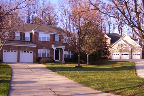
A 2000s-era subdivision in East County. Many of these homes lost value during the Great Recession and have yet to recover. All images by the author.
I grew up in downtown Silver Spring at a time when people were still moving away from urban centers. Twenty years ago, my neighborhood consisted of abandoned buildings and boarded-up stores, and in 1998, my parents started looking for houses outside the Beltway in places like Olney and Burtonsville, which seemed ascendant at the time. Besides, we were already driving to shop there. My parents found a little split-level house a mile from a new shopping center with a Target, Chipotle, and Starbucks.

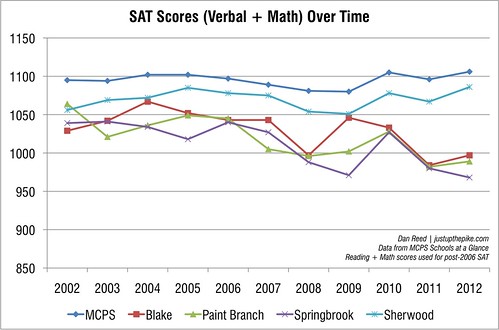
My high school, Blake, opened that same year, and most of my friends’ parents seemed to have made the same move from Silver Spring and Takoma Park. New subdivisions were popping up with big, luxurious houses, lush lawns, and names like Briarcliff Manor and Hampshire Greens. In the older neighborhoods, houses were sold for the land so big McMansions could rise in their places.
I remember going to a party at the end of high school where we sat in a circle bragging about how much our parents’ houses were worth. I was the odd one out because my parents’ house had appraised recently at a measly $500,000.

Abandoned House in Tanglewood
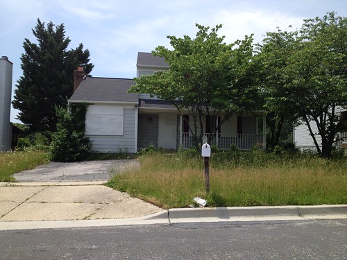
An abandoned house in an East County subdivision in 2014.
But it wouldn’t last; the Great Recession hit East County pretty hard. Burtonsville Crossing, the shopping center where we hung out in high school, is almost completely vacant. Some of my parents’ neighbors, unable to make ends meet, resorted to running illegal auto shops out of their homes, inviting relatives to move in, or renting out their basements.

Meanwhile, downtown Silver Spring had a comeback as more people sought urban living. A major redevelopment project along Ellsworth Drive brought restaurants, shops, movie theaters, and a Whole Foods. Montgomery County poured millions into new public facilities, including a library, the Civic Building, and Veterans Plaza. In response, private developers built thousands of new apartments and condominiums, including the building I live in now, a converted bottling plant that was still operating when I was a kid.

Here's how the real estate market in East County has changed

The real estate market shows how Silver Spring has bounced back from the recession while East County has struggled. Here’s a graph showing average home values in 2012 and 2017 as they compare to 2007 levels. It shows the two zip codes inside the Beltway, 20910 (Silver Spring) and 20912 (Takoma Park), and seven zip codes (mostly) outside the Beltway: 20901 (Four Corners), 20902 (Wheaton), 20903 (Hillandale) 20904 (Colesville, Fairland), 20905 (Cloverly), 20906 (Aspen Hill) and 20866 (Burtonsville).

How 2012 and 2017 home values in East County stack up to 2007 levels. Click on all of these graphs to enlarge them.

Home values all over East County fell during the Great Recession. In zip codes 20903 and 20906, home values fell by nearly half between 2007 and 2012. This year, average home values in the eight zip codes outside downtown Silver Spring are 71% to 85% of what they were a decade ago. But in zip code 20910, which contains downtown Silver Spring, values are actually a little higher than they were 10 years ago.

Home values inside the Beltway have recovered, but remain lower elsewhere. 

Homes inside the Beltway have been more valuable than those outside it for a while now. But the gap in home values has increased over the past 10 years. This graph shows the average home sale price per square foot, as a way to even out differences between houses of different sizes and styles. In the summer of 2007, the price per square foot in zip codes 20910 (Silver Spring) and 20866 (Burtonsville) were fairly close, at $363 per square foot and $304, respectively. Today, they’re $384 and $257; in other words, a difference of 50%.

Those who bought homes in East County before the housing boom, or at the bottom of the market, may have recovered their investments or even made a little extra. But those who bought at the top of the market saw their gains wiped away.
Homes in far-flung zip code 20905 linger on the market longer than homes closer in.

Another measure of demand is the number of days a house sits on the market. During the Great Recession, houses across East County languished for months due to a lack of buyers. In early 2008, the average house in zip code 20905 sat on the market for nearly six months. Demand returned, but not equally. In early 2017, homes in the 20910 zip code spent just 22 days for sale, compared to 59 days in 20905.

There's a huge opportunity in East County, but things need to change

Like many aging suburbs, East County is caught in the middle. The kids I grew up with have either moved to urban areas closer in, or moved farther out to newer suburbs in Olney or Howard County, aided by new highways like the InterCounty Connector that made it easier to commute longer distances. East County is a long drive from Montgomery County’s biggest job and shopping centers, which are all along Rockville Pike and I-270. And the local schools struggle with a negative reputation compared to their counterparts in more affluent areas.

Corner of Springvale Road and Ellsworth Heights Drive
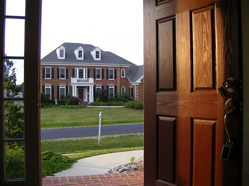
New townhomes in downtown Silver Spring, where home values are higher than they were in 2007. 
Yet the fact that homes here are much more affordable than in other parts of the county could be a big opportunity. Nationwide, some three million Millennial homebuyers have been shut out of the housing market because of high prices and a lack of supply. Millennials are open to living in suburban areas, but want stuff they can walk or bike to.

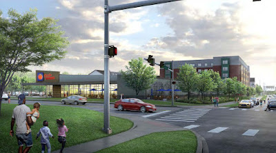
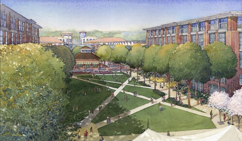
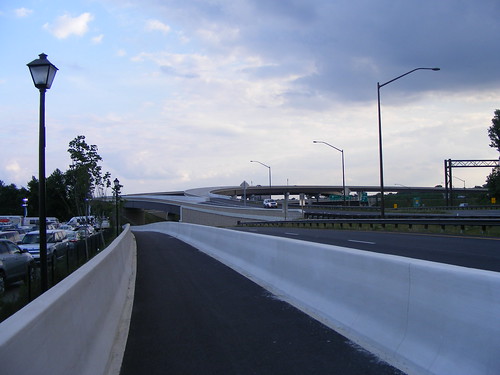
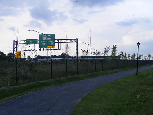
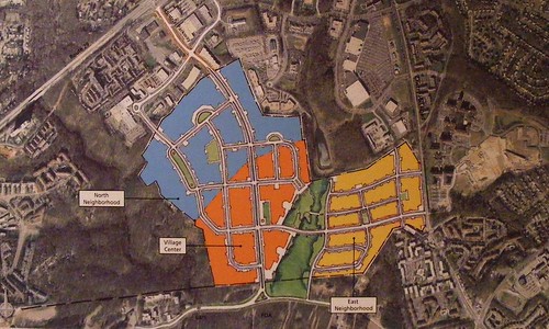
Providing that lifestyle in East County is imperative to drawing people and investment to this area, just as it did in Silver Spring. Montgomery County’s plans to create a walkable town center and research park in White Oak and a new village center in Burtonsville will bring the amenities people want, while a 
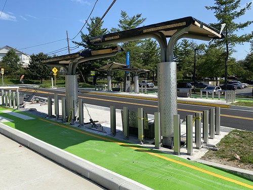
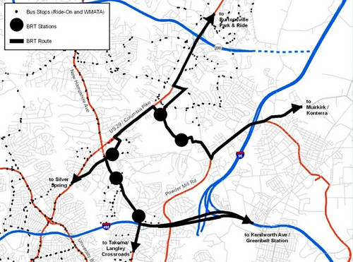
new BRT line on Route 29 will provide faster, more reliable transit. Combined, the two will give East County access to jobs, shopping, and economic opportunities.

East County has waited decades for the kind of prosperity the rest of Montgomery County takes for granted, and at great cost. Hopefully residents won’t have to wait much longer.

Friday, March 6, 2015

expand route 29 to build a sidewalk? why not just build the sidewalk

Maryland highway planners say four new interchanges on Route 29 in eastern Montgomery County will cut congestion, improve pedestrian and bicycle safety, and make it easier to build bus rapid transit. But the designs they've proposed would actually make all three of those things worse.

One of four proposed interchanges along Route 29 in Montgomery County, with north on the right side. Image from the Maryland State Highway Administration.

For decades, Maryland highway planners have been trying to turn Route 29 between New Hampshire Avenue in Montgomery County and I-70 in Howard County into a freeway. They recently unveiled new designs for a $128 million interchange at Route 29 and Fairland and Musgrove roads, just south of the Intercounty Connector. Today, both roads intersect Route 29, also known as Columbia Pike, at separate stoplights.

Under the state's proposal, Musgrove Road would become a dead end street on the west side of Route 29, while on-ramps and off-ramps would connect the east side of 29 to its northbound lanes. Fairland Road would go from four lanes to six and only have access to 29 going south.

If the project gets funding, construction could get underway in 2018.

Maryland has already built interchanges along Route 29 in Howard County and in Montgomery County at Cherry Hill Road, Briggs Chaney Road, and Route 198. In 2002, plans to build four more interchanges at Fairland and Musgrove roads, Stewart Lane, Tech Road, and Greencastle Road were put on hold and the focus shifted to the Intercounty Connector. In 2013, then-Governor Martin O'Malley revived the projects.

Tuesday, August 26, 2014

how did silver spring get its boundaries? and how would you define them?

You could ask five residents what Silver Spring's boundaries are and receive five different answers, ranging from a neighborhood near the DC line to a city the size of the District of Columbia itself. But how did it end up this way to begin with? The answer involves a railroad, zip codes, and possibly Marion Barry.
Silver Spring, as the Census Bureau sees it. Image from Wikipedia.


Unlike northeastern states where every square inch of land sits inside a municipality, or western states where cities compete for territory to access natural resources or tax revenue, much of Maryland and Virginia are unincorporated. Part of the reason is that counties in these states can perform functions like zoning and schools, reducing the incentive for communities to become a town or city.

Silver Spring is one those places. As a result, most definitions of Silver Spring fall into two camps: one I call "Little Silver Spring," or areas near its historical center, or "Big Silver Spring," which comprises most of eastern Montgomery County. To find out which one is more dominant, local organization Silver Spring Inc. will have residents draw their own boundaries in an interactive event at Fenton Street Market this Saturday.

Wednesday, February 5, 2014

east county residents want new jobs and transit in white oak

One thing was clear at last night's public hearing on plans to create a transit-oriented town center and biotech hub in White Oak: almost everyone wants more jobs and amenities in White Oak, even those who aren't comfortable with new development in their backyards.

Roundabout, LifeSci Village
LifeSci Village, a proposed research park in White Oak. Rendering from Percontee.

This month, the Montgomery County Council took up the White Oak Science Gateway plan, seeks to draw companies who want to be near the Food and Drug Administration's campus near Route 29 and New Hampshire Avenue. It proposes over 8,500 new homes and 40,000 new jobs in several urban neighborhoods, which would sit on three of the county's proposed Bus Rapid Transit lines.

Support for the plan was high, with 20 of 34 speakers in favor. As in a previous hearing at the Planning Board in May, residents were eager for new investment after decades of waiting. Even those who were skeptical of the plan's emphasis on transit and feared it would create a "tsunami of traffic" on Route 29 said East County needed the investment.

Monday, February 3, 2014

traffic concerns could tie up white oak science gateway plan

For decades, eastern Montgomery County has lacked the jobs and amenities the more affluent west side has long enjoyed. But plans to finally deliver those things, along with the transit to support them, could get hung up on concerns about car traffic.

Quad, LifeSci Village

The White Oak Science Gateway plan would transform sprawling office parks and strip malls around the Food & Drug Administration campus near Route 29 and New Hampshire Avenue into a town center and biotech hub. County officials say they've already heard from international pharmaceutical companies who want to be nearby.

With 8,500 new homes and over 40,000 new jobs, the plan would double what's on the ground today, and many are concerned about the traffic it might bring. County planners say that not doing anything won't get rid of White Oak's congestion, and that the real solution is to improve transit and bring people's daily needs closer to home. The County Council will hold a public hearing on the plan tomorrow night.

Wednesday, August 28, 2013

walking to school in montgomery county gets a little safer

A student at Bethesda Elementary School.
Photo by Ronit Dancis.
Last year, drivers hit nine people walking to school in Montgomery County, and residents are agitating for change. With classes starting this week, the county's Department of Transportation has taken a few small steps toward making the walk there safer, but it's not enough.

Tracy Simmons walks her two kids a mile to Bethesda Elementary every day. She says it's simply not safe, citing sidewalks too narrow to walk on, poorly-timed stop lights, and drivers who speed and don't yield to small children crossing the street. "Drivers need to stop thinking about their destination and be aware of what's going on around them," she says. "The streets are for everyone and everyone has the right to be safe while on them."

The Action Committee for Transit, a transit and pedestrian advocacy group, joined with the Washington Area Bicyclist Association and area parents to launch the Safe Walk To School campaign last spring, asking MCDOT to make small improvements that could make walking to school safer.

Thursday, June 27, 2013

northeast consortium an example of school choice gone wrong

Second in a series on segregation and academic equity in MCPS. Check out part ONE | part THREE | part FOUR

Each fall, thousands of 8th graders in Montgomery County participate in Maryland's oldest experiment in school choice, the Northeast and Downcounty consortia. Intended to prevent the school system's growing segregation, the consortia's 8 schools are not only more isolated than before, but academic performance has suffered.

NEC + Sherwood SAT
SAT scores have fallen at the Northeast Consortium high schools, while remaining steady at neighboring Sherwood and in MCPS as a whole.

Since the 1970's, MCPS has struggled to close the "achievement gap" between white and minority students and create more integrated schools. While officials had some success with magnet schools, in the 1990's, they sought a new approach with James Hubert Blake High School, which was being built near Olney.

Instead of redrawing the catchment boundaries, a long and controversial process, the Board of Education decided to let students integrate themselves by letting them choose among the new school and 3 nearby schools, Sherwood, Paint Branch and Springbrook. In 1998, the US Department of Education gave MCPS a $2.9 million grant to set up the Northeast Consortium.

Tuesday, May 28, 2013

white oak residents endorse science gateway plan

Quad, LifeSci Village


For years, the White Oak area north of downtown Silver Spring has struggled with disinvestment. Last week, residents, community leaders and major landowners endorsed a vision to bring jobs and people back.

Montgomery County planners recently finished a draft of the White Oak Science Gateway Master Plan, a proposal to turn the 1960's-era suburb that inspired The Wonder Years into an urban hub for scientific research. The centerpiece would be LifeSci Village, a partnership between developer Percontee and Montgomery County to turn a 300-acre brownfield into a mixed-use community.

During last Thursday's public hearing before the Planning Board in Silver Spring, all but a handful of the 35 speakers spoke in favor of it, highlighting the need to bring more investment to East County, which has lagged behind the rest of Montgomery County for decades. Many White Oak residents travel to Bethesda or the I-270 corridor for jobs or shopping, while some neighborhoods in the area grapple with crime and blight.


Tuesday, May 21, 2013

science gateway proposes an urban approach for white oak

Quad, LifeSci Village
LifeSci Village, a proposed bioscience research campus that's part of a new plan for White Oak.
50 years ago, White Oak was a prosperous suburb that inspired The Wonder Years, but today the community north of downtown Silver Spring struggles with disinvestment. Montgomery County planners say an urban approach to redevelopment can bring new life to the area.

While White Oak has several historically affluent neighborhoods, today it has no majority racial or ethnic group, and renters make up over a third of the population. There are abandoned office buildings and a reputation for crime, whether real or perceived. Residents have to go long distances to Bethesda, the I-270 corridor or DC for work, shopping or other amenities.

Planners found that residents are frustrated with the status quo. "There is great interest in seeing 'things happen'," they write in a draft of the White Oak Science Gateway Master Plan, a proposal to transform White Oak's strip malls and office parks into a "vibrant, mixed-use, transit-served" research and technology center.

Friday, April 19, 2013

a preview of our latest project


Sorry for the light posting this week. It's been a busy month for me on the job front, which I'll be able to go into more detail about in the future. I've also been working with the Coalition for Smarter Growth on a video about traffic along the Route 29 corridor, how it affects our daily lives, and how real improvements to our transit network can improve your commute and make East County a better place to live.

Posting will resume next week. In the meantime, here's a preview of the video, taken during rush hour Tuesday morning in Four Corners:

Friday, June 29, 2012

lack of connections, visibility hurt ICC trail

Looking Back at ICC Interchange


Less than a year old, the InterCounty Connector Trail offers a new way to get across Montgomery County by bike. However, a circuitous route, a lack of connections to surrounding areas and sections with poor visibility all hurt its potential.

The ICC was originally planned to have a bike trail running parallel to it, but in 2004, the State Highway Administration got rid of it, claiming it would reduce the toll road's construction costs and environmental impacts. Instead, they gave the ICC Trail a more circuitous and indirect route, running parts of it along the highway and the rest along local roads like Columbia Pike and Briggs Chaney Road.

Not surprisingly, area bicyclists were unhappy with the decision. "Why do designers think cyclists should have to go the long way, but cars need a direct route?" asks the WashCycle blog.

Part of the trail runs parallel to Columbia Pike between Fairland Road and Briggs Chaney Road in East County. Like the Forest Glen pedestrian bridge that crosses the Beltway, it runs under a highway. The trail is also lightly used and has already been vandalized.

This is unfortunate, because the trail could tie neighborhoods on both sides of the ICC together and is a crucial part of a "commuter bikeway" along Columbia Pike first envisioned in master plans 15 years ago. But this part of the ICC Trail won't get any busier or safer without better foot and bike connections to get people to it.

Let's take a look at the trail:

More Bike Trail


Here we are on the trail, just north of Fairland Road. That's the exit sign for the InterCounty Connector up ahead.

Little Seating Area


First we pass this small seating area. People do use it, judging from the abandoned pair of shoes. I enjoy the dry stacked stones and wooden bench, which give the trail a woodsy, rustic feel despite its surroundings. Behind the seating area is the recently-built Fairland View subdivision. It's separated by a grass berm and has no connection to the trail, despite being yards away. (The view, of course, is of the InterCounty Connector.) I assume these nearby chalk drawings came from kids living there.

Into the Tunnel


Now we're heading under the interchange between Columbia Pike and the ICC. This part of the trail is almost invisible from either road and the surrounding houses, and I passed a group of young men smoking right before I took this picture.

Sharpie Graffiti


There is Sharpie graffiti in the tunnel, though it's not much worse than anything I saw or did myself in high school. The tunnel appears to have been repainted a few times since it opened; in fact, since I took this photo, the scribbles have already been painted over. It's good to see that the state is maintaining the trail, though I wonder how regularly they patrol it.

Trail Just North of the ICC


After the tunnel, we go under a couple of overpasses. The roar of traffic is pretty intense, and I noticed some broken glass on the path where lights have been knocked out.

Heading Towards Briggs Chaney Road


We're now between Columbia Pike on the left, and the Montgomery Auto Park on the right. Turn around and you get a great view of the interchange. There are maybe waist-high concrete walls on either side of the trail and a chain-link fence separating it from the Auto Park. The wall might keep bicyclists safe from car traffic, but I wonder if it's also there to protect the car dealerships from bicyclists.

Around the Auto Park


And then we hit a wall. This is the interchange of Columbia Pike and Briggs Chaney Road, which was completed about four years ago; the trail takes a hard right to get around it and then joins Briggs Chaney Road.


Trail Ends at Briggs Chaney Road


Across the street is the Briggs Chaney Plaza shopping center; there's a stoplight and intersection in front of us, but no pedestrian signal or even a crosswalk. From here, we can continue down Briggs Chaney, which has a nice, wide shared path for about a mile and a half before connecting to a portion of the trail that's actually on the ICC.

Residents of Tanglewood, a subdivision on the south side of the ICC, complained that a trail would invite "criminals" from the apartment complexes along Briggs Chaney Road. While I still think that accusation was unfair, residents' predictions that there would be vandalism on the trail turned out to be true.

But as WashCycle points out, the best way to make a safe trail is to make it busy. In the handful of times I've used this one-mile portion of the ICC Trail, I've seen maybe a dozen people there. The trail is new enough that some people haven't heard of it, but it's also obscured by a highway interchange and sound berms.

It would've been ideal if the State Highway Administration had laid out the trail first and then worked around it, rather than the other way around. The trail would be more direct, and possibly more visible, while having little or no effect on the ability of drivers to pass through.

Since that opportunity no longer exists, the best thing we can do is to improve foot and bike connections to nearby destinations like Briggs Chaney Plaza and neighborhoods like Castle Boulevard, which recently got new sidewalks and medians. The easier it is to walk or bike in the area, the more likely people are to use the ICC Trail, and the less destructive behavior will occur.

Check out this slideshow of my bike ride along the ICC Trail and other roads in East County.

Monday, January 9, 2012

adorable purple line video, and introducing #welcometosilverspring

Whether to gin up support for the Purple Line, or to remind folks it's still being planned, the Maryland Transit Administration created this awesome video. I can't think of another piece of public transit, new or existing, as adorable as the Purple Line looks in this clip.

My favorite part? A brief cameo from Chompy the shark, shown in his natural state hanging from the Discovery Building despite going on hiatus last summer:


The video depicts the Purple Line and its major destinations in a cartoon version of suburban Maryland, in which houses are scattered helter-skelter across the landscape and giant words occupy the center of each town. (In Silver Spring, of course, they already do.) Naturally, liberties are taken with the Purple Line's route as well. Here it is scooting down what appears to be a cartoon Georgia Avenue:


The actual Purple Line will go down Bonifant Street and Wayne Avenue in downtown Silver Spring, but there is talk about bringing D.C.'s proposed streetcar up Georgia Avenue into Maryland, so hopefully this will get people excited for that as well.

ANYWAY: I'd like to try an experiment with y'all. The other day, I was at Target on Cherry Hill Road and I saw a group of teenage boys performing a synchronized dance in and around a Cadillac Escalade with diplomat tags. I thought to myself, "Only in Silver Spring."

I'm curious what other things you see that make you think the same. That's why I started using the #welcometosilverspring hashtag on Twitter. If you use Twitter and find something that seems unique to Silver Spring, use it. Here's a feed of tweets currently using the #welcometosilverspring hashtag:


As of press time, there are only three tweets, two of which are mine. I'm looking forward to seeing what y'all come up with.

Tuesday, December 13, 2011

lifesci village still far from being a reality

Quad, LifeSci Village
A new rendering of LifeSci Village.

Last week, Montgomery County selected local developer Percontee to turn Site 2, a former sludge treatment plant in White Oak, into LifeSci Village, a $3 billion mini-city designed to compliment the Food and Drug Administration's new campus and a new Washington Adventist Hospital. Despite a series of sexy new project renderings released by Percontee, East County's answer to Cambridge isn't a guarantee yet.

LifeSci Village, which we first wrote about in 2009, would occupy 290 acres on Cherry Hill Road east of Route 29. In addition to the sludge plant, which closed in 1999, the site would include a concrete recycling plant owned by Percontee. Genn has previously said that the project would include roughly two million square feet of offices and research labs, two million additional square feet of shops, hotels and possibly a conference center, and between three and four thousand apartments and townhomes.

LifeSci Village Site Plan
2009 site plan of LifeSci Village.

Genn has been talking to the county about LifeSci Village and Site 2 since 2004, so it's not surprising that they picked Percontee over two out-of-area developers less familiar with the project. But in 2009, he told me that a groundbreaking was "not anytime soon." The Post, meanwhile, says that construction could start within the next two years.

What's changed? Last year, the MoCo Planning Department started work on the White Oak Science Gateway Master Plan, which will reinforce LifeSci Village's goal of creating a research hub around the FDA. In addition, the county is studying a Bus Rapid Transit network which could have several lines serving the development.

MoCo BRT Plan, White Oak
BRT lines under study in and around White Oak.

Though LifeSci Village has the blessing of both the county and local residents, the White Oak Science Gateway concept has its critics. A study from economic consultants hired by the MoCo Planning Department says that it won't work unless it can get a major research institution, though Genn says he's talked to "very prominent" D.C.-area universities about locating there. Even then, the consultants say, biotech companies might just continue going to the county's other research and development district, the Great Seneca Science Corridor in Gaithersburg, which Percontee helped develop in the 1980's and where Johns Hopkins University plans their own, similarly-minded "Science City" project.

As exciting as the LifeSci Village proposal is, there remain a lot of questions. Who will provide $3 billion in financing for a research campus without a research institution? Is it practical to build 4 million square feet of commercial space and 4,000 homes in an area with no fixed-rail transit? And will Montgomery County be able to lure biotech companies away from the vaunted "Technology Corridor" along I-270?

East County needs a project like this. But it's not yet clear if LifeSci Village will ever go from being a pretty picture to a reality.

Wednesday, November 2, 2011

MoCo may be diverse, but it's not integrated yet

Last year, Montgomery County became majority-minority for the first time. But our neighborhoods aren't as integrated as they could be, threatening the county's ability to grow and prosper.

On Sunday, the Post featured a cover story on newly-diverse suburban neighborhoods across the United States, focusing on the Hillandale neighborhood of Silver Spring:
From one end of McGovern Drive to the other, and on adjacent streets, a boundless diversity continues: immigrants, or their offspring, from Jamaica and Haiti, Egypt and Israel; African Americans who have lived there for 20 years; and whites who bought their homes when Lyndon Johnson was president.
Since 1999, my family's lived in Calverton, which like Hillandale a few miles away was until recently a predominantly-white community. In 1990, whites made up almost three-fourths of Calverton's roughly 11,000 residents. Though the neighborhood has grown by more than half since then, whites and blacks make up equal shares of its population, at about 39 percent each. The Asian population's been steady, but the Hispanic contingent has tripled to become one-tenth of the community. Check out this graph (it may not add up to 100% because Hispanics are counted as an ethnicity, not a race):
 

Demographic Shift in Calverton


Yet as Montgomery County becomes more polyglot, it's not necessarily integrated. Two years ago, my brother graduated from Galway Elementary School in Calverton. Its nearly 800 students are half black, a quarter Hispanic and just 4.3 percent white. In a neighborhood where the median household income is $76,000 a year and the average home sells for nearly $400,000, 60 percent of students are on free or reduced lunch. In addition, test scores are generally lower than they are at elementary schools elsewhere in the county.


Galway Elementary School Sign (In Spanish)
Signs at Galway Elementary are written in English and Spanish. Photo by Mark Doore, Calverton Citizens Association.

Where are Calverton's white and middle-class residents? Some of our neighbors have moved away to Rockville or Olney, which are generally more affluent and have higher-rated public schools. Those who remained chose to "opt out" of the system, putting their kids in private school. They also take part in other exclusive amenities, like the members-only Calverton Swim Club across the street from Galway. A quick look at the club's website reveals a mirror image of the school:
 
Calverton Swim Club
The membership of Calverton Swim Club remains predominantly white, though the neighborhood isn't. Photo by Mark Doore, Calverton Citizens Association. 

This isn't necessarily a problem for our family. My parents are very involved in my brother's education and are generally happy with his experience at Galway and now at Briggs Chaney Middle School, which is slightly more diverse. While my family aren't members of the Calverton Swim Club, we can go to the nicer and public Martin Luther King, Jr. Pool, which has water slides and a lazy river.

At the same time, it's generally recognized that the United States will cease to be a predominantly-white nation in about thirty years, and we're seeing the beginnings of that in Montgomery County. This actually puts us in the catbird seat: if we're going to compete in a global society, we must be able to understand and react to cultural differences. Your kids might be having birthday parties with Salvadorian, Iranian and Korean kids today, but they're preparing themselves to do business with people from those countries in the future.

Montgomery County has the ability to use its polyglot population as a strength, to create better, unified communities and draw investment and ideas from around the world. Yet it's frequently thwarted when more fortunate residents try to keep the less privileged out or, as in Calverton, "opt out" of the community altogether.

For years, the Columbia Country Club and the Town of Chevy Chase has fought to keep the Purple Line out of their community. A community group in Silver Spring tried to remove a soccer field in a local park because Hispanic teams from outside the neighborhood were using it. And neighbors in Bethesda had a vacant home demolished rather than letting a homeless family live there. These actions may benefit a small minority, but in the end, they hurt everyone.

This county's long had a reputation for progressive politics due to our affordable housing program and agricultural preserve. As a result, we tend to take diversity for granted, assuming that having Hispanic Heritage Month each October or occasionally eating ethnic food in Wheaton is enough. (Meanwhile, some are afraid to eat in Wheaton at all.) But this isn't enough. In order to fully take advantage of the county's diversity, and to ensure that everyone has a place here, we have to create truly integrated communities.  


World Cup Fever On Ellsworth
This might just look like a game, but it represents the future of Montgomery County.

How can we do this? We have to work even harder to create an equitable school system, ensuring students in affluent "Green Zone" schools and struggling "Red Zone" schools get the same level of education. Meanwhile, we have to continue investing in older communities like Silver Spring where "Red Zone" schools are located to give people the option of staying rather than moving further out and self-segregating.

We have to create neighborhoods that are accessible to a broad swath of the population, by providing a mix of housing styles and prices. In addition, we have to make it safer and easier to get around by foot, by bike and by public transit, which benefit all residents, not just those who can afford a car. And we have to make everyone feel welcome here, instead of scapegoating immigrants or teenagers

Most importantly, we have to have the political wherewithal to do these things, rather than capitulate to groups who fight to preserve the status quo.

It's been a long time since Montgomery County was the "perfect suburbia," and it's not always clear what we'll become. Nonetheless, we have the opportunity to become something even greater. It won't be easy, but if we want to ensure the county's continued prosperity, we don't have a choice.

Friday, October 28, 2011

a new name isn't enough for east county science center


East County Science Center Open House
Admiring a map of the now-renamed White Oak Science Gateway.

Area residents and businesspeople wanted a new name for the East County Science Center, an area bounded by New Hampshire Avenue, Columbia Pike and Cherry Hill Road where county planners seek to draw research and development firms seeking to be near the new campus of the Food and Drug Administration.

The new moniker? Welcome to the White Oak Science Gateway.

The name first appeared a month ago, when members of an advisory committee for the plan raised concerns about how vague "East County Science Center" was. From the Gazette:
“What’s East County?” Stocks [Jere Stocks, president of Washington Adventist Hospital] said. “It could be anywhere. ... The name really didn’t fit. I think what we have now, it puts us on the map in terms of national perspective.”
I've long used "East County" to describe the communities I talk about on this blog, because they're all unincorporated (meaning they lack their own government or strict boundaries) and there often isn't a better term. Many people in this part of Montgomery County (we'll define it as "everything east of Rock Creek Park") say they live in Silver Spring, and I support that, though people who live closer to downtown Silver Spring have other ideas. Of course, this doesn't work if you live in Burtonsville or Olney or Takoma Park, which all are generally recognized as places in their own right, or in a place like White Oak, which has a much weaker identity.

If we want to draw companies from around the country and around the world to a science park which right now exists only on paper, it has to have a compelling name. Everyone recognizes Cambridge or Silicon Valley or the Research Triangle. "East County Science Center," as Jere Stocks points out, could be anywhere in the world.

This isn't the first time that MoCo's tried to rename a place. While working for Councilmember George Leventhal last year, I got to help think of a new name for the Gaithersburg West Master Plan, another area where planners want to create a home for research and development. The problem with the name "Gaithersburg West" was that the area it covered wasn't so much "west of Gaithersburg" as it was a bunch of unincorporated areas surrounding the City of Gaithersburg with no connection or relationship to each other.

My suggestion was to call it the Great Seneca Science Cluster, because Great Seneca Highway ran through at least some parts of the master plan area, and it was a name that ordinary people would recognize. It stuck, even though "Cluster" became "Corridor." The name isn't perfect, but it sounds like it could be a place, and if everything goes as planned the Great Seneca Science Corridor will actually be a place.


Harvard Square
Cambridge, Massachusetts: A great name for a place, but also a significant destination for scientists and researchers around the world.


Will the White Oak Science Gateway be so lucky? I worry. I wouldn't have picked the word "Gateway," personally, because it suggests something that you enter or pass through, not a place that you go to. More significant is the issue that Montgomery County will now have two science parks, each sort of in competition with each other. Consultants hired by the Planning Department to look at the White Oak Science Gateway's merits concluded that the plan will fail unless there's a substantial reason for companies to consider locating there instead of at Great Seneca or somewhere else entirely. 

Names have a powerful ability to give places character - or in the case of "East County," to take it away. But while it's important to ensure that Montgomery County's new development areas have compelling names, it's worthwhile to ensure that they also become places worth naming. Planners are holding an open house on the East County Science Center White Oak Science Gateway Master Plan tonight at

Friday, June 17, 2011

metro considers new subway, light-rail lines for east county

Transit geeks across East County are certainly salivating over this recently-posted report (PDF!) from Metro's Office of Long Range Planning, which lays out not one but four (!!!) new light-rail and subway lines that could criss-cross the area by 2040.

Well, sort of. As explained on the transit agency's blog, Metro is looking at possible expansions for their Regional Transit System Plan, which will cast a vision for the system in 2040. They've created a Technical Advisory Group that wil l review each of the proposed new lines or extensions for their feasibility. Some of the things Metro is looking for are projects that increase capacity in downtown D.C., where trains are nearing capacity; that connect to "new and emerging markets" not currently served by rapid transit; and improve service along "surface transit corridors," like buses or light-rail lines.

Metro's latest round of proposals include the four aforementioned lines serving East County, some or all of which could make their way into the Regional Transit System Plan and, hopefully, see the light of day. They are:

Metro - DC Streetcar Expansion

An extension of one of the eight proposed DC Streetcar lines, currently slated to end at Takoma, to the Silver Spring Transit Center.

Metro - CCT, Purple Line & Purple Line Spur

The Purple Line Spur, first proposed by County Councilmember Marc Elrich several years ago, which would run from a Purple Line stop in Langley Park to White Oak and Burtonsville via New Hampshire Avenue and Route 29.

Metro - Capital Beltway Line

A Beltway Line, a subway line that would run parallel to the Capital Beltway, with stops at White Flint, Wheaton and White Oak. This was originally part of a study conducted in the 1990's that led to creation of the Purple Line.

Metro - Proposed Brown Line

The Brown Line, an entirely new subway line between Friendship Heights, downtown Silver Spring and Calverton via downtown D.C. In East County, it would run beneath Route 29 with stops at the Silver Spring Metro, Four Corners, White Oak and Cherry Hill Road.

The study also included Montgomery County's proposed Bus Rapid Transit system, which would include sixteen routes, eight of which would serve East County.

Are the proposed lines realistic? Yes and no, but they suggest that Metro is taking East County's transportation needs seriously. We'll take a further look at the report, and its findings, next week. In the meantime, what do you think? Would you want to catch the "Brown Line" to White Oak?

Wednesday, June 15, 2011

tale of two newlywed couples

Montgomery County's at a strange crossroads now. As an older suburb, once-pristine neighborhoods are starting to look worn out and suffer from disinvestment. Meanwhile, other areas are turning into urban enclaves, but they don't provide all of the amenities that traditional city neighborhoods offer. The result? MoCo's fighting a battle on two fronts.

An example: In the past year and a half, three of my friends from high school have gotten married. Both couples (two friends married each other) are a demographic any place would kill for: twentysomething, educated, high-earning couples, eager to find a place where they can put down roots, at least for a few years. Both couples like going out, seeing new places, and trying new things. And though we all grew up a few miles apart, both couples are moving out of Montgomery County, which no longer provides the lifestyle they want.

One couple just married in March and are already expecting a child. She works in Baltimore; he works at Fort Meade. Currently, they're living with her parents in Calverton, but they're looking for a house in Howard County. Why? It's closer to their jobs, closer to shopping in Columbia, closer to Korean BBQ in Ellicott City.

Big Houses, River Hill (1)
Is Howard County a better deal than Montgomery for those seeking the ultimate suburban experience?

Housing isn't necessarily cheaper. After all, HoCo is the fifth-wealthiest county in the United States. But though the house in our old neighborhood might cost the same as similar house in Columbia, the schools are likely better, the massive Columbia Association's maintaining the common areas, and Route 32 won't get as congested as 29 or the Beltway (at least, not yet).

In short, Howard County has out-suburb'd Montgomery.

The other couple married last winter. He's a graduate student at the University of Maryland; she works for an IT company in Old Town Alexandria. For the past two years, they lived in an apartment in Hillandale. Neither of them are keen on driving, so living in the shadow of the Beltway made it hard to get around. Much as they enjoyed hanging out in downtown Silver Spring, they were attracted to the wider array of bars, restaurants and shops in Alexandria, not to mention the ability to travel exclusively by foot, bike and transit.

Last month, they moved to an apartment in Carlyle, a new neighborhood being built around the Eisenhower Avenue Metro. They can literally see the trains from their window. A block away is a complex of shops, restaurants and a movie theatre. One stop on the Yellow Line takes them to a really good Thai place on King Street, and another stop to their favorite taqueria in Del Ray.

Mix massing mixed-use Carlyle Alex
Alexandria's Carlyle neighborhood provides a stronger urban experience than anywhere in Montgomery County currently offers. Photo by faceless b on Flickr.

In this case, Alexandria has out-city'd Montgomery. You'd expect this, because Alexandria's been a center of commerce for over a quarter-century. But would you expect Montgomery to lose its much-treasured status as the "perfect suburbia" to Howard County?

Montgomery's older suburban neighborhoods are losing out to newer communities on the fringe, which have more money to invest in schools and infrastructure and less to spend on maintenance and social issues. Meanwhile, urban centers like downtown Silver Spring and downtown Bethesda can't always compete with their counterparts in Arlington, Alexandria and the District, which offer more activity, more housing choices, and more transportation options. Montgomery County will compete with both of these places for residents, businesses and tax dollars, and it has to compete with both if it's going to survive.

It's easy to demand the status quo. But let's look at where the next generation is going. Are we creating a place where young professionals and new families want to live? And can we actually offer a compelling alternative to new suburbs and old cities alike? If we can find the answer, I've still got plenty of single friends looking for a place to live.